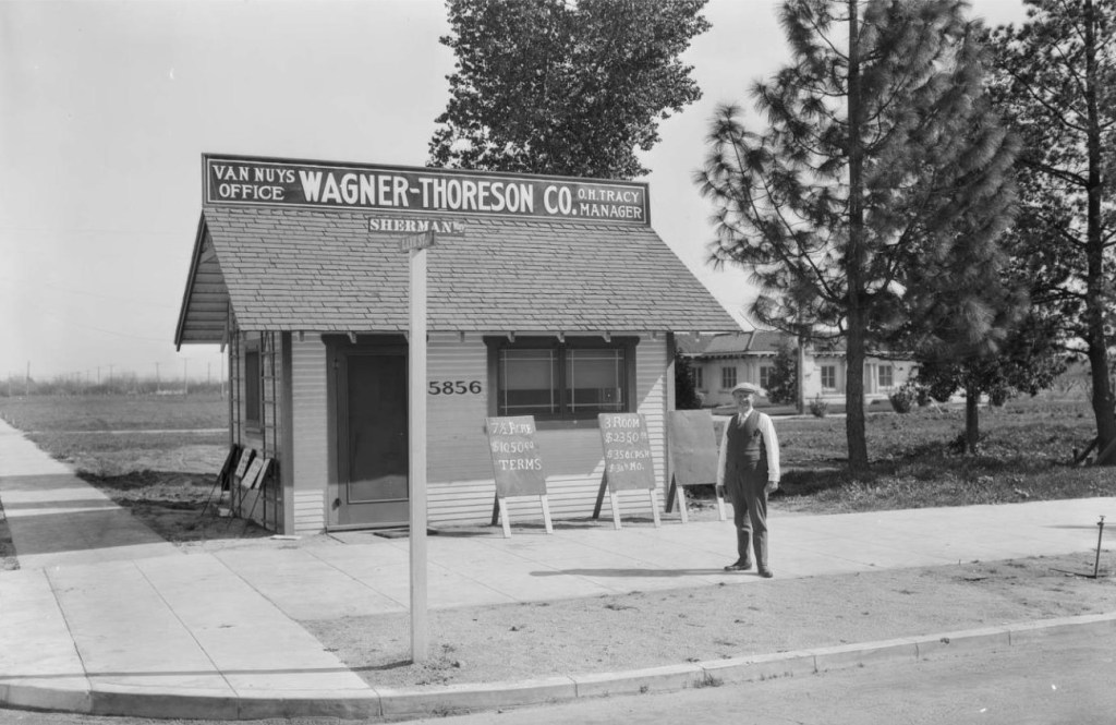
Clearing Up a Photo Mystery


I found a DWP  Collection photo from the 1920s that shows the Van Nuys office of “Wagner-Thoreson Co.” (a realty company) and a nattily attired man standing in front. 

In the background is an estate on a large piece of land. A signpost reads: “Sherman Way” and “Lane St.” The photo had some information underneath which said “Lane St. was later renamed Califa St.” 

Where exactly was this? 

On Google Maps there is not a “5856 Sherman Way.” I thought the signpost might be blocking a number “1” so I inputted “15856 Sherman Way” but that address, in present day Valley Glen, was not at an intersection.  Califa and Sherman Way do not intersect either.

The 1926 San Fernando City Directory listed “Wagner-Thoreson Co.” at 5856 Van Nuys Bl. (at Califa). Not “5856 Sherman Way.”

Then I remembered something. 

Sherman Way was once the route of the Pacific Electric streetcar. The PE snaked its way up through the Cahuenga Pass into North Hollywood, then west down Chandler Blvd. It turned north up Van Nuys Blvd. and then travelled to go west on Sherman Way.

But Chandler Blvd. and Van Nuys Blvd. did not exist in name until 1926. From 1911 until 1926 Chandler, Van Nuys and Sherman Way were all named: South Sherman Way, North Sherman Way and Sherman Way!

On May 25, 1926, the Los Angeles City Council, with some infighting between San Fernando Valley residents, came to a compromise and agreed to partition the Sherman Way family into three distinct names: Chandler, VNB and Sherman Way.  


So the man in the mystery photo is standing on present day Van Nuys Blvd. at Califa, a block south of Oxnard.

Van Nuys Bl. 1930

Pacific Electric service lasted until December 29, 1952. 

Cahuenga Pass 12/29/52
N. Hollywood, CA. 12/29/52
Chandler Bl. 12/29/52

These sad and wondrous Kodachrome photos from the collection of Caesar “CJ” Milch (not the original photographer) show the #5146 car that once ran up through the Cahuenga Pass and into the eastern San Fernando Valley on its last day.

A Great Wall on Burbank.


“Building-to-street proportion is the relationship between the height of buildings on either side of a street and the width between those buildings. An ideal proportion between these two creates a pleasant and visually interesting public realm. The public realm, therefore, may be considered as an “outdoor room” that is shaped by 
the “walls” of the building heights and the “ floors” of the roadway.

Outdoor rooms with excessively wide roadways or short building heights tend to eliminate any sense of enclosure
 for the pedestrian.”
-Los Angeles Small Lot Subdivision Design Guide, 2014

Our city, with its sprawling boulevards and speeding cars, is often cursed with roads way too wide for pedestrians. Think of six-lane Van Nuys Boulevard, bordered by one-story high buildings, and worse, parking lots.

In some areas of the city, like on Pico Boulevard and in Studio City along Ventura Blvd. planted islands with trees now break-up the wide asphalt. New “outdoor rooms” with a sense of enclosure and protectiveness emerge. These are deliberate and designed for upgrading ugliness.

But sometimes even an ongoing construction project can enlighten and transform a bleak stretch of formerly wide street monotony.

In North Hollywood, on Burbank Blvd. just east of Vineland, DWP has been tunneling and installing a new water delivery system.

Processed with VSCOcam with a5 preset Processed with VSCOcam with e2 preset

And along part of the route where a deep, underground hole was dug, DWP erected 20-foot high, wood and metal-framed walls. It has temporarily transformed the commercial district of that area by slicing the four-lane road into a two-lane and creating, along the sidewalk, a European type shaded alley.

Processed with VSCOcam with a1 preset

Work Area #12, as it is officially known, requires a pit to launch a tunnel-boring machine that will travel south, along Lankershim Blvd. for more than a mile. A new water pipeline will replace the aging 1940s infrastructure.

While the construction is going on, some streets have been closed off, which no doubt contributes to aggravation and inconvenience for some area residents and businesses. But the rerouting and reconfiguration has some pleasant side effects.

On Burbank Blvd. cars now stop twice, before proceeding slowly, down a narrow road whose borders are shaded by high walls and low buildings.

Processed with VSCOcam with e1 preset Processed with VSCOcam with a1 preset
On the western edge of the excavation, two tanks tower above the road, as if heralding a ceremonial gateway into the neighborhood.

And on the south side of the street, the high walls come right up to the sidewalk, creating a shady and meandering path alongside area businesses.

The gift of this unwelcome intrusion allows us to experience a different LA with traffic calming elements. What emerges? Less cars, slower drivers, shaded walkways; walled off from the exhaust fumes and the aggression of speeding motorists. Industrial construction materials in steel, wood and concrete function as street sculpture.

For the time being, a stretch of Burbank Boulevard is a living experiment in rezoning by accident.

Processed with VSCOcam with a1 preset Processed with VSCOcam with a1 preset