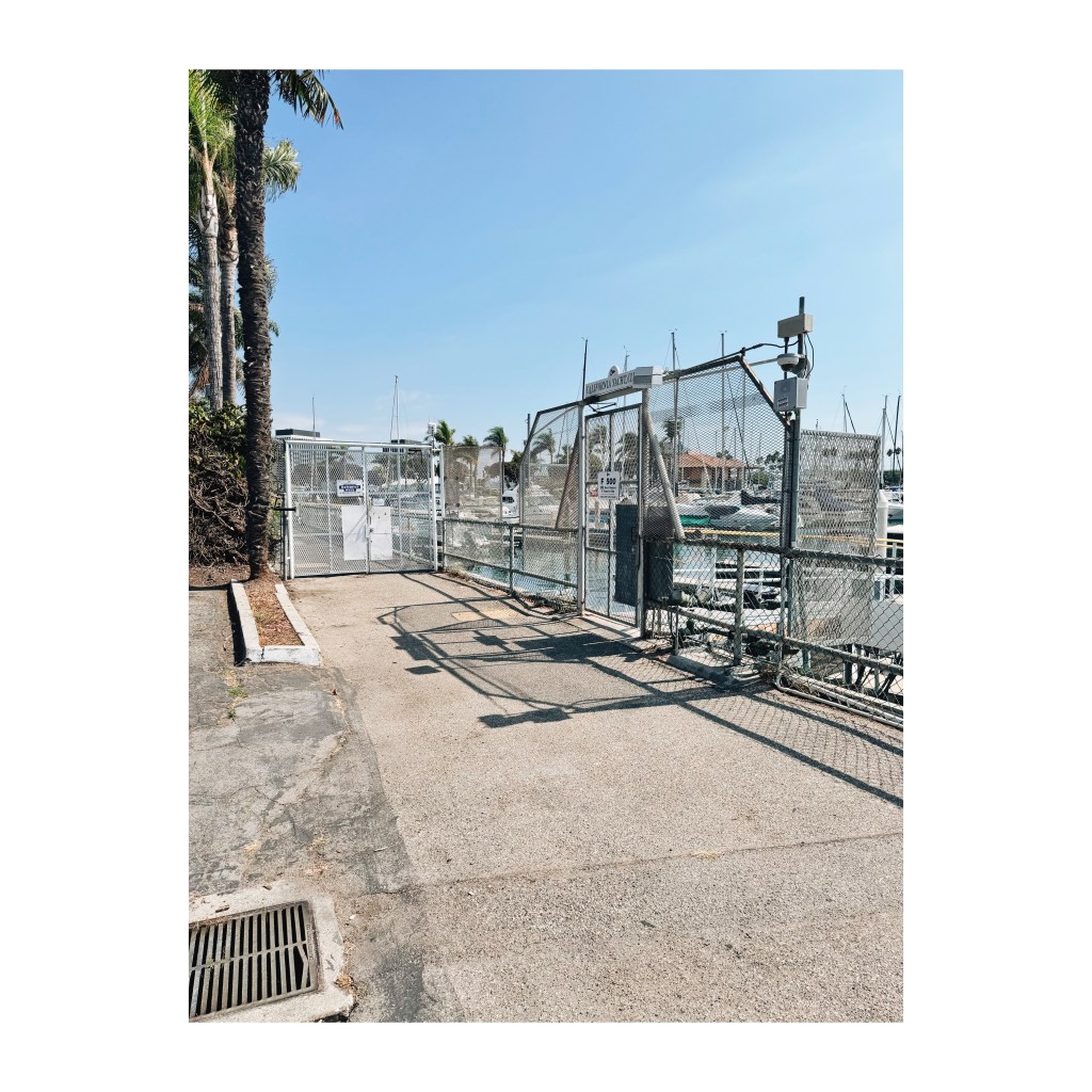
Navigating Public Space in Marina Del Rey.


In the 1960s, the swamps of south Venice became a multi-million dollar building project that culminated in what we now call Marina Del Rey.

Pleasure boats, yacht clubs, nautical facilities, circular high rises with balconies overlooking the harbor, landscaped roadways with palm trees, office buildings, pharmacies, tennis courts, a hospital, a fire station, a library; and many restaurants overlooking the yachts, sailboats and motor boats.

A district devoted to tanning, drinking, carousing, love making, and living the good life amongst airline pilots, stewardesses, restaurant workers, aspiring actors, and retirees. The 1960s dream of accessible pleasure for anyone white with a convertible.

They even built the 90 Freeway to get people in fast, before the boat left the dock. Imagine the high quality of life 60 years ago, when a new freeway was affordable and considered the highest and best use of land.

From its inception, Marina Del Rey feigned a public purpose while raking in the dollars fencing off the best parts for private use of yacht clubs and apartment dwellers. Docks are locked up and there are many barriers to prevent the use of the harbor for the general public unless you are there to purchase a dinner and drinks on a boat, bar or restaurant.

Over the years, there have been community projects to create usable public space, such as Yvonne B. Burke Park on the north side of Admiralty Way which has athletic equipment, bike roads and jogging paths. That park too has recently been incarcerated when Bay View Management built a cinder block wall that closed a public access point behind a Ralph’s store on Lincoln Boulevard. 

God forbid a pedestrian in a park might access a supermarket on foot.

Other luxury apartments, understandably fearful of crime, vagrancy and violence, have illegally built obstructions along their land to prevent the park from becoming a way to enter their properties.

Every few hundred feet, the green parks become parking lots. An athlete running, riding a bike or rolling skating will eventually stop at a busy road where vehicles speed by at 60 miles an hour. And other cars and trucks will be entering the parking lots or exiting, creating additional hazards for the non-driver.

The big, popular restaurants, anchored in seas of asphalt, offering seafood, steak, alcohol, valet parking, and private parties to corporate diners and red nosed, melanomatous men in Tommy Bahama, have all gone out of business. Café Del Rey and Tony Ps with their crumbling, dated, Brady Bunch style restaurants are empty. The cigarettes, cigars, Aramis and lounge singers gone with the wind.

The great pandemic meltdown which has stolen our lives, taken our movie theaters, pillaged our department stores, and defecated upon our civic dignity, has now obliterated the big dining establishments of Marina Del Rey.

These popular places, that seemed immune to time, forever serving enormous plates of grilled lobster, prime rib, baked potatoes, cheesecake, ice cream sundaes and voluminous cocktails are now dead. Silent as Hiroshima after the bomb, these outposts of high on the hog, intoxicated living were ailing, out of fashion, and are now exiled from our spartan, self-consciously healthy era.


For a pedestrian who is trying to stroll one mile of the harbor west from Bali Way to Palawan Way, with the boats in view along the south walkway, there are several private obstructions that make it impossible to complete the walk.

I speak from experience as my friend Danny and I did the walk today.

The California Yacht Club locks up the walkway with their own use of the property. 

One is forced to detour to Admiralty Way with the unused parking lots of the long-gone restaurants on one side, and the near-death experience of speeding cars on the other.

To reenter the harbor walkway, you find the Los Angeles County Fire Department Station #110 (4433 Admiralty Way) and walk behind the building to rejoin the path along the water to once again enjoy the public recreational qualities that are supposedly there for everyone to enjoy, not just yacht members.

The Marina City Club encompasses three early 1970s high rises which are entered securely by several guarded driveways on Admiralty Way. This complex has swimming pools, tennis courts, a convenience store, but is threatened by similar structural defects that brought down the Surfside, Florida condominium in 2021, killing 98 persons.

For now, residents who own property there pay high HOA fees, and even those who bought in cheaply face repairs that will surely cost collectively in the hundreds of millions of dollars to make these three, 55-year-old buildings safer in a location where tsunamis and earthquakes are always visiting unexpectedly.  

Concluding the walk today, we went north along a dirt path on the west side of the Oxford Basin “Wildlife Refuge” which connected to Washington Boulevard.

As we passed a vagrant man sprawled on wall, shopping cart and garbage nearby, my friend Danny shouted, “Get going, walk faster.”

Danny had spotted a handgun in the vagrant’s hand.  

Just another reminder, if any is needed, that nobody should assume that this is a safe area, regardless of how much homes sell for. The demoralizing and unsanitary aspects of Los Angeles are all around, because we live in perhaps the dirtiest metropolis in the United States, one that believes public trash camping is a civil right and mental illness is only a danger after it kills.

How this city will present during the 2028 Olympics is something Orwell would have pondered.

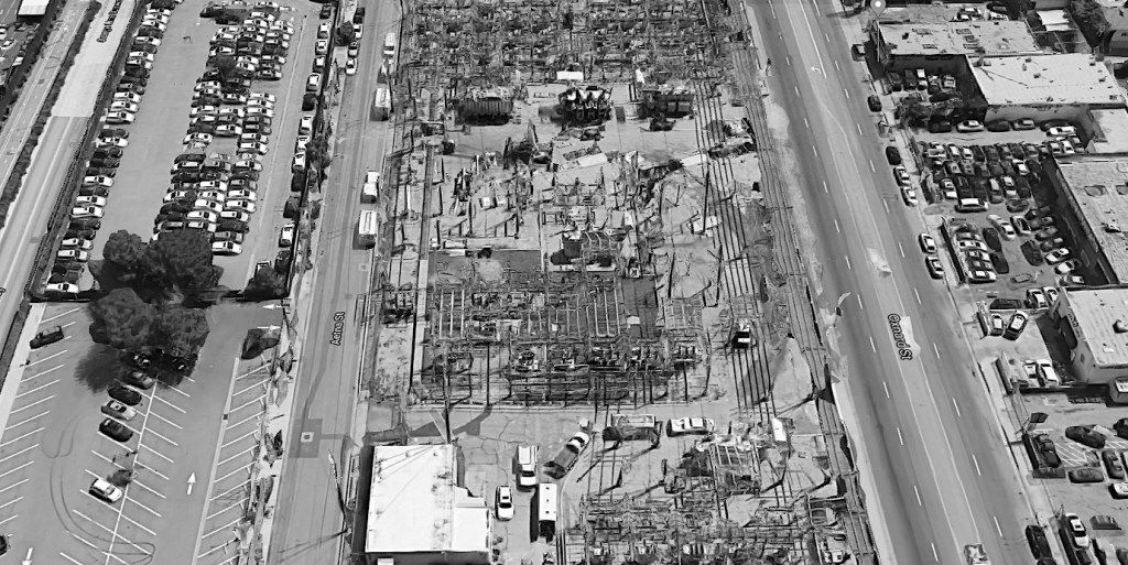
Van Nuys: City of Parking Lots


Between Oxnard and Vanowen, on either side of Van Nuys Bl. fully 75% of the land is taken up, not by buildings, but parking lots.

Near Oxnard, on both sides of the Busway, parking lots are used mostly for storage of unsold, new cars from nearby Keyes dealerships.

Along the civic center, there are enormously underused concrete parking lots, several stories high, built in the 1960s.

Civic Center Parking

Moving north, beyond Vanowen, near Kittridge, there are wide open parking lots behind shuttered businesses where perhaps 25% of the spaces available are used for cars.

Think about these parking lots when people complain that Van Nuys is too crowded, that we don’t have room for more apartments, that we don’t have space to house homeless persons, that we cannot find room for parks, that we simply don’t have land for urban gardens or nature spaces.

Think about these parking lots, see them in your head, when people complain that there is nowhere to park, that we spend too much time in traffic, that our air quality is low, that we are baking in a hot area where there are not enough trees even as the Earth warms.

11 Ideas to Improve Van Nuys.


For almost twenty years I’ve made a home in Van Nuys, CA.

And since 2006, I have published this blog: walking, photographing and writing about a peculiarly blessed, and unjustly afflicted section of Los Angeles.

Here are some 11 ideas that I am proposing to better Van Nuys, especially Van Nuys Boulevard:

Kjellandersjoberg_salabacke_view-courtyard.

Create Walkable, Garden Court Housing

We need, desperately, little, affordable, small housing units that share common garden areas. These were built all over Los Angeles up until the 1960s when dingbats took over with their car-centric designs.

Such garden courts would be most effective within walking distance of major bus and light rail streets.


LAPD Koban (Japanese Style) booth at The Grove.

Relocate the Van Nuys LAPD to Van Nuys Boulevard

The Van Nuys LAPD is buried deep behind the Erwin Street Mall, way back from Van Nuys Boulevard. What this accomplishes is removing the police from active interaction with pedestrians, shops and the action, good and bad, on Van Nuys Boulevard. Putting the police station back on the boulevard where it belongs would send a message to the community that law enforcement is on active duty: watching and patrolling, enforcing the law.


Reduce the Size of Wide Streets and Plant Trees

When drivers see five lanes of road in front of them, but every single lane is packed with cars, or conversely, when there are wide-open lanes with few vehicles, both scenarios create frustration. The speeding, the road rage, the frustration of having so much space for cars and hardly any for bicycles or light rail, has caused the decay and decline of Van Nuys Boulevard, as well as Victory.

The heating up of our climate, the constant hot weather, is creating a meltdown of mood, with more anger, more violence and more irrationality. Trees would help cool down the street and provide shade. Narrower streets, lined with cafes, pedestrians, activity, would build a sense of community decency.


58277232 – singapore – march 18, 2016 : maxwell food center is the maxwell road hawker food centre is well known for its affordable, tasty and huge variety of local hawker food.

Hawker Centers Like Singapore

Singapore has “Hawker Centers” which are groups of different food merchants housed under one roof. A Singaporean can get off a train and within a few feet find delicious, cheap food in clean areas which are protected from the elements but still open air.

By contrast, Los Angeles has nothing like this other than Grand Central Market which is not next to a train stop.  Van Nuys Boulevard would greatly benefit from one, large, enclosed, regulated building full of food sellers. This would bring the pushcart under control and provide a clean, reliable, fun, sociable place to eat and meet.

Billboard: Sepulveda at Victory

Give Commercial Buildings Without Billboards Tax Breaks

Billboards are so ubiquitous that we have wearily come to adjust our eyes to them. Yet their ugliness, their cheap, desecrating, looming presence brings down property values even while providing landlords with some income.

On every corner where there is a mini-mall with a billboard, the property owner who removes the signs should get a tax benefit because they are helping the community improve aesthetically.


A Monument When Entering Van Nuys

Why is there no marker, like an arch, an obelisk, or a gate when one enters Van Nuys Bl. at Oxnard Street?

Imagine a Washington Monument type obelisk in the center of Van Nuys Boulevard to make evident, proudly, commemoratively and architecturally, the fact that Van Nuys is a historic and proud area of Los Angeles deserving its own marker of identity and purpose.

Seen for miles, an obelisk perhaps 150 feet tall, should stand in the center of the boulevard, a booster of morale and an instigator of commerce and civic pride.

Santa Barbara, CA.

Pick a Unifying Style and Stick With it.

Paris, Santa Barbara, Charleston, Savannah: certain cities have an archetype of architecture which provides the base for how a city is constructed and designed.

In recent years, we have seen the onslaught of non-conforming, strange, computer-generated frivolities in architecture such as those which have marred and destroyed the beauty of London, England.

Yes, it is great to have one Disney Hall, but a street of melting blobs, narcissistic designs, starving-for-attention buildings, does not engender a district wide identity.

Strange Shaped Building: Vienna, Austria.

A classical Van Nuys would actually be revolutionary because it goes against so much architectural dogma these days and restores the primacy of community standards and group identity.


 Tear Up the Parking Lots and Plant Orange Groves

One of the tragedies of Van Nuys since 1945, indeed of all of Southern California, has been the loss of agriculture.

Once we all lived near local fruit groves, and their soothing, healthful, beneficial trees provided not only big business for the state, but gave a mythical, blessed countenance to Los Angeles which was exported around the world.

There are hundreds of acres of unused asphalt sitting behind empty stores along Van Nuys Boulevard which could be torn up and planted with citrus trees.

Perhaps an innovative architect could design housing that is combined with citrus groves?


Kester and Aetna

Kesterville

This blog has actively supported the preservation of an area of 33 acres, containing light industries, near the corner of Kester and Oxnard.

“Option A” would have destroyed 58 buildings, 186 businesses and thousands of jobs in a walkable, affordable, diverse district and replaced it with an open air, light rail service yard.

It would have been disastrous for the revitalization of Van Nuys. If it had succeeded it might have been the final nail in Van Nuys’ coffin.

Instead, happily, the Metro Board, with the support of Councilwoman Nury Martinez and others, objected to the Option A proposal. “Option B” was chosen, near the already existing Metrolink train tracks, thus preserving the Kesterville area.

So now is the time to put Kesterville on the map and make it a harmonious, vibrant destination of little apartments, stores, restaurants, cafes, all along the public transit corridor next to the Orange Line.

Pashupatina: Ivan and Daniel Gomez in their shop which they completely renovated with their own hands and money in 2015.

Create Gateway Signs to Welcome People to an Area. Kesterville could use one of these!


9 Houses and 24 bioclimatic collective housing units
by Fleury, Benjamin / Photo: Emmanuelle Blanc

Paris-Housing-by-Vous-Etes-Ici

9 Houses and 24 bioclimatic collective housing units
by Fleury, Benjamin / Photo: Emmanuelle Blanc

9 Houses and 24 bioclimatic collective housing units
by Fleury, Benjamin / Photo: Emmanuelle Blanc


Remove Onerous and Expensive Regulations on Housing

Builders are required, by law, to do so many expensive things that they are dissuaded from building.

One example is parking. The average building must spend 30-40% of its construction costs to provide space for vehicles.

Thus we have the paradox: not enough housing. And the housing we have becomes more expensive because there is not enough of it to bring prices down. And each rentable unit only becomes affordable if four working adults, with four vehicles, split the rent!

So now we have less housing, more cars, more cars parked on side-streets because we have, by law, made the construction of apartments so expensive.

Remove parking minimums and stop catering to the car as if it were the ONLY important thing in city planning.If a building were built with 200 apartments and only 100 parking spaces, would it really harm Van Nuys?

Is NYC harmed by scarcity of parking?

Homeless on Aetna St. Feb. 2016

Regulate Homelessness

California is often the destination for anyone living unhappily in any part of the world. Thus our state, because of its warm weather, attracts people coming here to escape.

Van Nuys, long considered the unofficial dumping ground of Los Angeles, is now under onslaught from homeless men and women sleeping everywhere, on bus benches, under boxes and tents, behind buildings and in RVs parked along the street.

We need to regulate where people can sleep by providing safe, clean, sanitary areas, to park RVs and where people can wash themselves, and get help so they do not have to sleep outside.

To talk about this is not to attack people who are in need. Rather, it is to assign us the proper legal and moral task of ending homelessness by not permitting it to exist in the first place.


Unsafe Intersection: Columbus and Victory.


Victory and Columbus: Unlit

Gilmore and Columbus: Lit.

The corner of Columbus and Victory, on the north side of Victory, is one which has a constant stream of both traffic and pedestrians. But at night, the unlit intersection is a dangerous place, where cars turning north onto Columbus often narrowly miss nighttime bicyclists and people walking in the dark.

A few years ago, I contacted the City of LA about this, and was told, ridiculously, that a petition would need to be signed by area residents to request a street lamp at the busy corner. Yet, just north on Columbus, at Gilmore, Roya, Hamlin, Haynes, Kittridge and Vanowen, all are magically illuminated.

Many people walk at night in this area. And to keep them in the dark is to invite death or injury.

Pedestrian Friendly LA?


Century-City-Condo, originally uploaded by Here in Van Nuys.

From Project for Public Spaces:

“L.A. County has begun to rewrite the “DNA” of its streets with a new Model Streets Manual that will set guidelines to support improved safety, livability and active transportation options.

This effort was supported through a grant from the Los Angeles County Department of Public Health, through its RENEW initiative. RENEW stands for “Renewing Environments for Nutrition, Exercise and Wellness.” It’s inspiring to see a health-focused organization embrace a leadership role in Placemaking by broadening the scope of its concern to include planning for the built environment.

There is a growing understanding that streets configured to support an active lifestyle can lead to positive community health outcomes.

As Streetsblog reports, team lead Ryan Snyder of Ryan Snyder Associates has said the manual is like “the DNA of our streets, and it defines everything from where to place bike lanes to how wide a roundabout should be.”